Local Wildlife Gallery
Old Parish Maps
Local Links
E-Say NO to Overdevelopment HERE
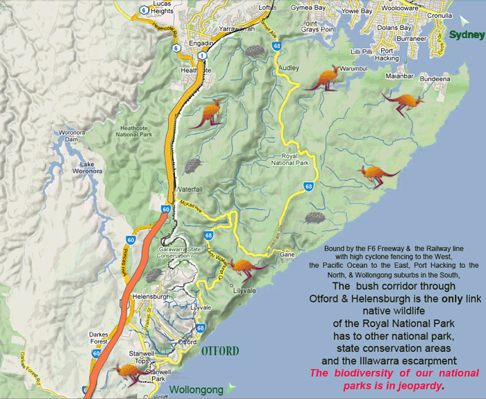
What Otford & Helensburgh mean to Sydney & the Illawarra
 |
 |
 |

Precincts & Locations of 7D land - proposed for Development &/or Conservation (as determined by WCC)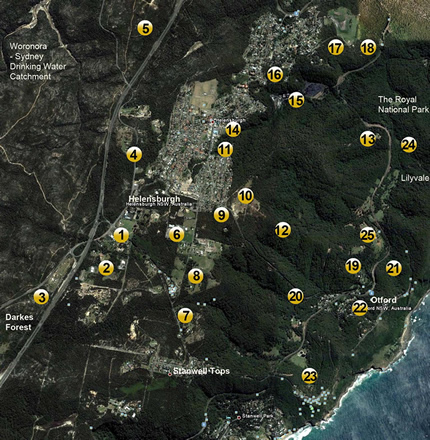 |
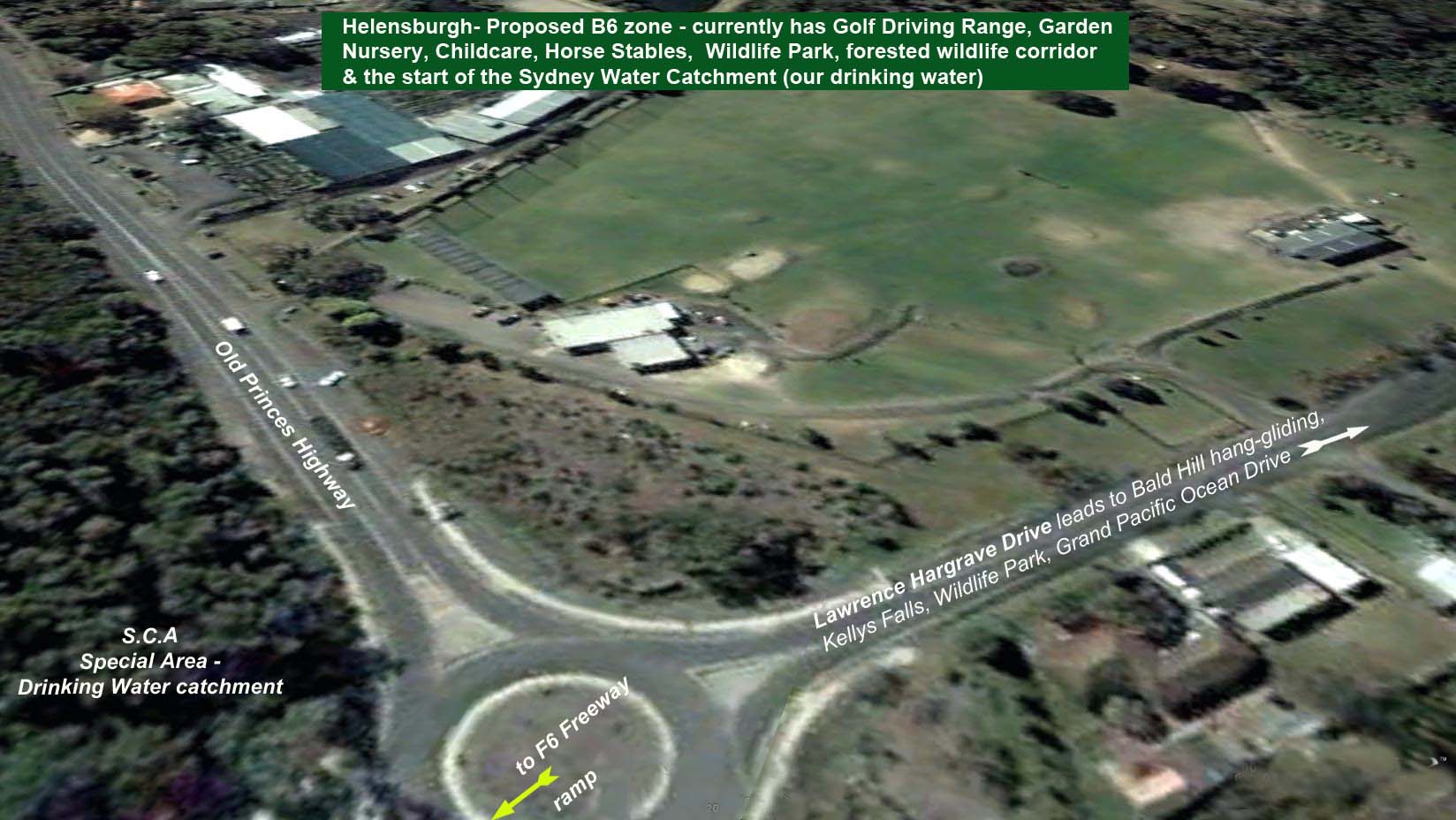
1. Gateway -Princes Hwy LHGD - B6 |
|
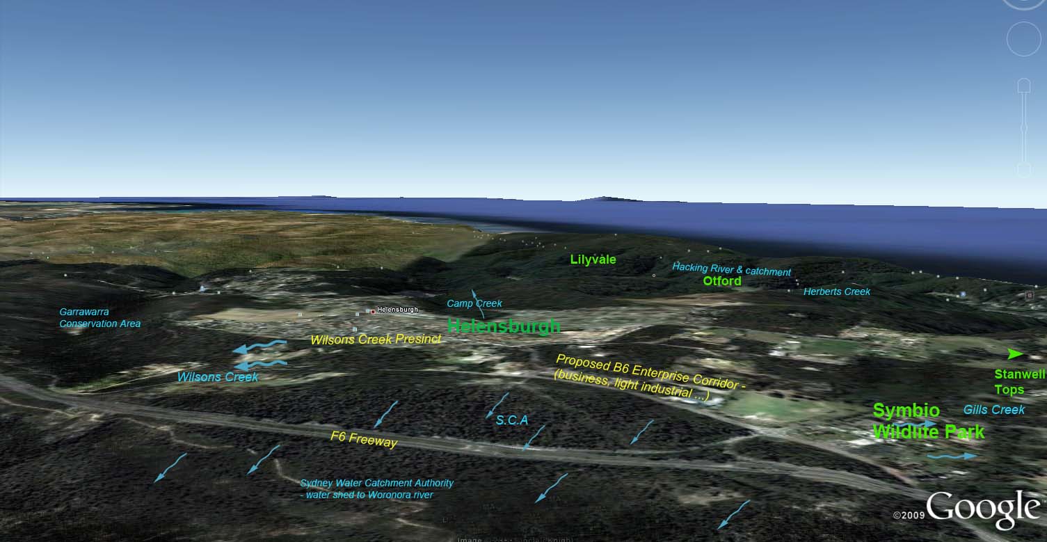
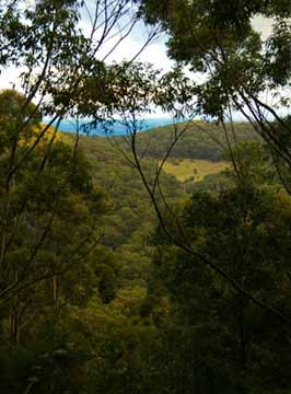
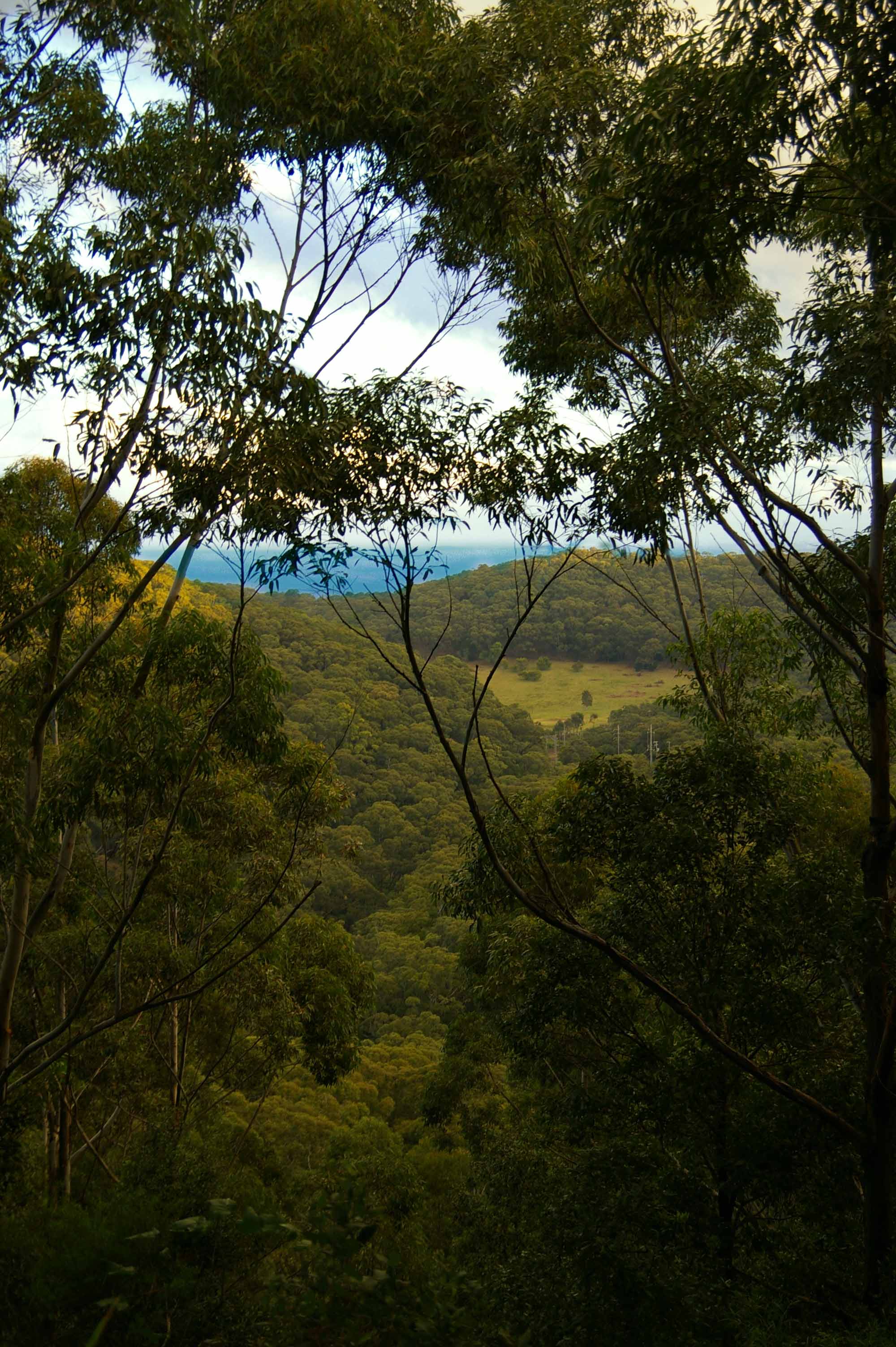
| View to Helensburgh Land Pool & LCE from Otford & the Grand Pacific Drive | ||
|
|

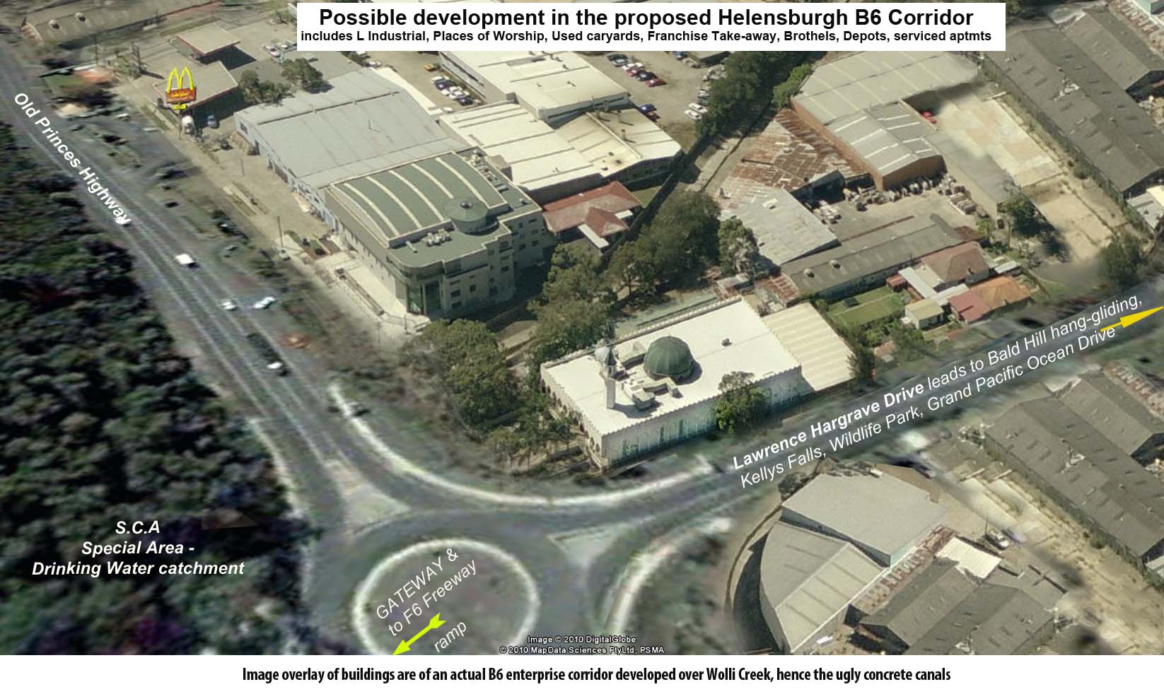
The photo directly
above is the 'Gateway' from the F6 freeway to Helensburgh, Otford,
Stanwell Park & Stanwell Tops & the
main thoroughfare to hang-gliding and views at Bald Hill,
Kellys
Falls, a Wildlife Park & meets the Grand Pacific
Drive, yet
WCC thinks it
should be a B6 corridor allowing mixed business from Light Industrial
to caryards and brothels, as depicted in the 'artist impression - right
hand photo!
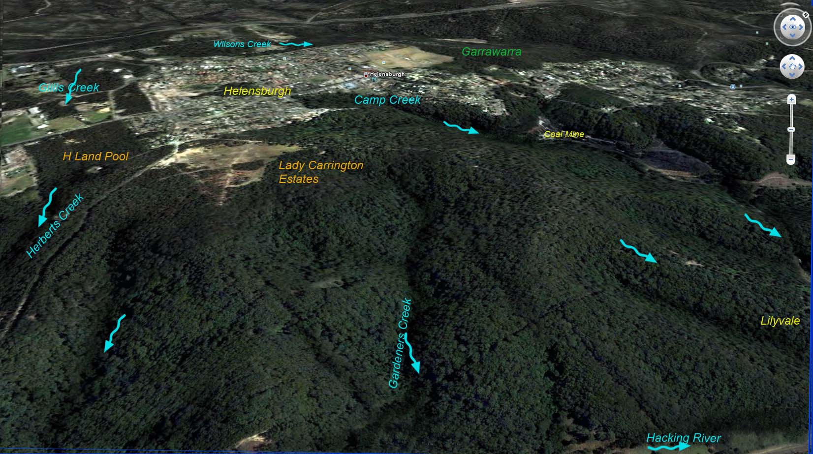
But this beautiful green buffer to the Royal National Park is at risk from developers! B6, E3 & E4. These zonings allow new buildings on land, where no building right ever existed! - which will result in barren earth land, polluted & eroded river catchment & destroyed riparian corridor, native wildlife eradicaton including endangered species, increased pollution and feral pests, & ultimately strangle the biodiversity of the Royal National Park. What ever can flow, roll, crumble or blow on the Helensburgh plateau will eventually end up in the valley and river
Wollongong City Council and NSW Dep Planning gazetted the WCC LEP 2009 in February this year, implementing the new zoning terms and respective restrictions. However most controversial was the translation of the former high conservation 7D zoning into E3 rather than the original applicable E2. E3 under NSW state planning allows new dwellings and various land uses. Even if minimum lot size clauses are applied, the E3 zoning does not prevent land clearing, degradation, high boundary fences, or even livestock damage. Some of the prescinct areas marked for E3 straddle tributary creeks on the edge of the Helensburgh plateau, in a direct line of sight from the Grand Pacific tourist drive. Given the high rainfall of the region, a terrain of clay and coalwash on a sandstone base, and existing negative urban impact held in check by the forest buffer, land clearing would cause enormous soil run-off, and a marked increase in sediment, nitrates and effluent in the tributary creeks and Hacking River
 INSIDE:
» Gallery of
wildlife in Otford, Helensburgh & Stanwell Park:
Gallery of
wildlife in Otford, Helensburgh & Stanwell Park:
» WCC Preliminary Summary & Recommended Amendments to 2010 LEP
» Otford Protection Society Incorporated Gateway Proposal ( 3 versions)
» Large view of proposed new zoning in Otford & its impact on the Royal National Park
» Map of 'interim' zoning gazetted Feb 2010 for 2508 & wrongfully changed from 7D
» Parish, county and old paper subdivision maps
» NPANSW
(National Parks Association NSW) Submission to WCC on the 7D
rezoning(1.8mb PDF)
NPANSW
(National Parks Association NSW) Submission to WCC on the 7D
rezoning(1.8mb PDF)
Information on Precincts & e-form letters to Wollongong City Council
 7D
PRECINCTS stop over-development of the Helensburgh/Otford/Stanwell
Park
7D
PRECINCTS stop over-development of the Helensburgh/Otford/Stanwell
Park
OTFORD
PRECINCT »
E-submission letter to stop over-development of the Otford Precinct
GATEWAY PRECINCT- B6 Enterprise Corridor - Princes Hway & Lawrence Hargrave Drive
WILSONS CREEK PRECINCT- Princes Hwy to Parkes St
GILLS CREEK PRECINCT- B6 & Industrial Corridor - Princes Hway & Lawrence Hargrave Drive
E-submission
letter to stop over-development of the 7D Precincts
E-submission
letter -personalise to stop development on the precincts especially
important to you
Please Note: Utmost care is taken to publish only factual material and links to relevant government publications and interest groups in respect to the 2508 region and adjoining national parkland. The present lifestyle, wilidlife corridor and clean environment with a relatively low density popuation are highly valued by the current ratepayers/residents, who wish to ensure those attributes are not devalued. We will not accept any liability for defamation in relation to third party material on this website, or linked to or from this website. If any current included material or link is of concern, parties are welcome to email requests for removal or edit and reasons for doing so
But this beautiful green buffer to the Royal National Park is at risk from developers! B6, E3 & E4. These zonings allow new buildings on land, where no building right ever existed! - which will result in barren earth land, polluted & eroded river catchment & destroyed riparian corridor, native wildlife eradicaton including endangered species, increased pollution and feral pests, & ultimately strangle the biodiversity of the Royal National Park. What ever can flow, roll, crumble or blow on the Helensburgh plateau will eventually end up in the valley and river
Wollongong City Council and NSW Dep Planning gazetted the WCC LEP 2009 in February this year, implementing the new zoning terms and respective restrictions. However most controversial was the translation of the former high conservation 7D zoning into E3 rather than the original applicable E2. E3 under NSW state planning allows new dwellings and various land uses. Even if minimum lot size clauses are applied, the E3 zoning does not prevent land clearing, degradation, high boundary fences, or even livestock damage. Some of the prescinct areas marked for E3 straddle tributary creeks on the edge of the Helensburgh plateau, in a direct line of sight from the Grand Pacific tourist drive. Given the high rainfall of the region, a terrain of clay and coalwash on a sandstone base, and existing negative urban impact held in check by the forest buffer, land clearing would cause enormous soil run-off, and a marked increase in sediment, nitrates and effluent in the tributary creeks and Hacking River
 |
Wollongong City Council are
requesting responses from the public to their recommended amendments to
the 2009/2010 LEP for the 2508 region
by August 16, 2010. Some of the areas/precincts have been rightly recommended to E2 high conservation, which we need to Submit our agreement (to negate Developers' submissions disagreeing with the E2 zone). But too many precincts have been zoned to allow hazardous new development, which of course needs our disapproval submitted. To
make it easy for you to have your say please add your name
to one of our e-submissions
to
Wollongong City Council & with any extra
comments you'd care to make Email
to WCC
|
 |
 INSIDE:
»
Gallery of
wildlife in Otford, Helensburgh & Stanwell Park:» WCC Preliminary Summary & Recommended Amendments to 2010 LEP
» Otford Protection Society Incorporated Gateway Proposal ( 3 versions)
» Large view of proposed new zoning in Otford & its impact on the Royal National Park
» Map of 'interim' zoning gazetted Feb 2010 for 2508 & wrongfully changed from 7D
» Parish, county and old paper subdivision maps
»
NPANSW
(National Parks Association NSW) Submission to WCC on the 7D
rezoning(1.8mb PDF)Information on Precincts & e-form letters to Wollongong City Council
7D
PRECINCTS stop over-development of the Helensburgh/Otford/Stanwell
Park OTFORD
PRECINCT »
E-submission letter to stop over-development of the Otford Precinct GATEWAY PRECINCT- B6 Enterprise Corridor - Princes Hway & Lawrence Hargrave Drive WILSONS CREEK PRECINCT- Princes Hwy to Parkes St GILLS CREEK PRECINCT- B6 & Industrial Corridor - Princes Hway & Lawrence Hargrave Drive E-submission
letter to stop over-development of the 7D Precincts E-submission
letter -personalise to stop development on the precincts especially
important to you
W.C.C
contracted a survey earlier this year on Council performance, opinion
and resident concerns. The survey results returned an overwhelming
88.2% of residents placing a high importance on the Protection of
Natural Environment.

Please Note: Utmost care is taken to publish only factual material and links to relevant government publications and interest groups in respect to the 2508 region and adjoining national parkland. The present lifestyle, wilidlife corridor and clean environment with a relatively low density popuation are highly valued by the current ratepayers/residents, who wish to ensure those attributes are not devalued. We will not accept any liability for defamation in relation to third party material on this website, or linked to or from this website. If any current included material or link is of concern, parties are welcome to email requests for removal or edit and reasons for doing so